Log in
All resources
Create a design
11,660 Free Images of Old Map
bibliothèque nationale de france
description de l'universe
alain manesson mallet
wikipedia course at maastricht university, january 2023
maps of limburg by aegidius martini
maps of spain by tomas lopez
maps from gallica
maps from the earth and its inhabitants, vol. iv
old maps of navarre
1772 maps of spain
maps of spain by tomas lopez
old maps of navarre
maps of spain by tomas lopez
old maps of navarre
maps of spain by tomas lopez
1766 maps of spain
maps of spain by tomas lopez
old maps of navarre
atlas ou representation du monde universel t. 2 (1633)
old maps of the republic of genoa
maps in the library of congress
old maps of antigua and barbuda
map of paris by braun & hogenberg - derivative files
rue montmartre (paris)
gemeente atlas van nederland - groningen
old maps of groningen (city)
details of old maps of amsterdam
jan roodenpoortstoren
old maps of deventer
atlas de wit 1698
wikipedia course at maastricht university, january 2023
maps of limburg by aegidius martini
wikipedia course at maastricht university, january 2023
maps of limburg by aegidius martini
wikipedia course at maastricht university, january 2023
maps of limburg by aegidius martini
wikipedia course at maastricht university, january 2023
maps of limburg by aegidius martini
géographie générale; physique, politique et économique (1876)
1870s maps of germany
dessin du château de brest
old maps of brest harbours
old maps of strasbourg
place broglie
maps in the british museum
old maps of leeds
prints and drawings of nijmegen
valkhof, nijmegen
construction drawings in the stadsarchief amsterdam
old maps of amsterdam
baupläne der kunstakademie düsseldorf
1873 in düsseldorf
maps in the amsterdam museum
1690s maps of palestine
nouvelle géographie universelle, vol. xii
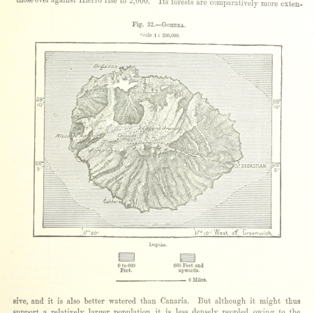
old maps of la gomera
siege of bergen-op-zoom 1622
old maps of north brabant
geometrischer grundriss von frankfurt am mayn (1811)
maps of frankfurt-innenstadt
maps by willem and johannes blaeu
old maps of middelburg, zeeland
landais & oberthur
maps from gallica
17th-century maps of crete
old maps of candia
old maps of finistère
maps from gallica
wikipedia course at maastricht university, january 2023
maps of limburg by aegidius martini
old maps of brielle
atlas van loon
miniature speed atlas (1627) pieter van den keere
old maps of the orkney islands
atlas maior, vol 5 (england) - joan blaeu, 1667 - bl 114.h(star).5
17th-century maps of norfolk, england
old maps of the environments of paris
maps by alexis-hubert jaillot
old maps of namur (province)
1640s maps of belgium
old maps of the viceroyalty of new spain
1570s maps of mexico
portsmouth earthworks maps
squier and davis images
print room of the university of antwerp
kaarten van vlaanderen (prentenkabinet)
bibliothèque municipale de reims, rès. g 153
baroque
bibliothèque municipale de reims, rès. g 153
baroque
1704 works in germany
old maps of ulm
celeberrimi fluvii albis nova delineatio by willem janszoon blaeu
old maps of germany from deutsche fotothek
maps from the earth and its inhabitants, vol. xvii
anton francesco lucini
1808 in galicia (spain)
galiciana
voyage de découvertes aux terres australes
old maps of australia
magni ducatus lithuaniae
history of ukmergė
internet archive document dayswaysinoldbos00ross 0
days and ways in old boston (1915)
paintings by charles c. wood taylor
1830s history paintings
maps by jodocus hondius
old maps of nassau
maps of france by hendrik hondius
old maps of cambrai
the trouvelot astronomical drawings
old maps of mars
description de l'universe
old maps of greece
old maps of south africa
maps of the great trek
plan de roussel - derivative files
cimetière ancien d'ivry-sur-seine
old maps of hainaut (province)
1590s maps of belgium
17th-century maps of switzerland
maps by pieter van der keere
a voyage to abyssinia, and travels into the interior of that country, executed under the orders of the british government in the years 1809 & 1810
john outhett
kastell budapest-albertfalva
danubius pannonico-mysicus
engravings from michael strogoff by charles barbant
illustrations from michael strogoff by jules férat
maps from gallica
guides joanne
keshcarrigan
lough scur
allgemeiner postatlas von der ganzen welt
old maps of italy
too late for gordon and khartoum (1887) by macdonald
old maps of the nile
old maps of rome
antonio lafreri
maps from gallica
old maps of rouen
maps in the library of congress
pre-raphaelite brotherhood
maps in the library of congress
1850 maps of new york (state)
maps from the earth and its inhabitants, vol. iv
maps of loch fyne
maps from the earth and its inhabitants, vol. vii
maps of the yellow river
maps from the earth and its inhabitants, vol. xiii
ethnographic maps of africa
maps from the earth and its inhabitants, vol. iv
mouth of tay
maps from the earth and its inhabitants, vol. iv
maps of kirkwall
engravings from michael strogoff by charles barbant
illustrations from michael strogoff by jules férat
historical images of tarragona
anthonis van den wijngaerde
atlas van der hagen (volume 3)
atlas van der hagen
old maps of la gomera
1878 maps of spain
maps from the earth and its inhabitants, vol. iv
old maps of the lake district
nuovo atlante geografico universale
old maps of southeast asia
1803 in berlin
1803 maps
maps from the earth and its inhabitants, vol. xiii
maps of weather and climate of south africa
old maps of utrecht (city)
atlas van loon
the comprehensive history of england (1876)
english-language maps showing history
description de l'universe
old maps of scotland
description de l'universe
old maps of north america
old maps of the united states
description de l'universe
maps of africa in the robert c. williams paper museum
1665 maps of africa
flandria illustrata
old maps of deinze
gemeente atlas van nederland - north brabant
old maps of bergen op zoom
maps by bernard ratzer
maps by thomas kitchin
old maps of the viceroyalty of new spain
the spanish borderlands
très riches heures du duc de berry
early netherlandish painting
cartouches by willem and johannes blaeu
maps made in the 17th century
description de l'universe
old maps of lemnos
description de l'universe
old maps of french guiana
description de l'universe
old maps of canada
description de l'universe
old maps of cádiz
cc-pd-mark
gold
bibliothèque municipale de reims, rès. g 152
old maps of saint-quentin
1840s maps showing history
maps by thomas starling
maps by john cary
1799 maps
9001 - 9100 of 11,660
Next page
/ 117


![Gerardi Mercatoris and I. Hondii Atlas or Representation of the Universal World, and of the Parts of It, Made in Tables and Very Ample Descriptions. [t. 2].](https://cdn.creazilla.com/illustrations/10000735247/gerardi-mercatoris-and-i-hondii-atlas-or-representation-of-the-universal-world-and-of-the-parts-of-it-made-in-tables-and-very-ample-descriptions-t-2-sm.webp)


![Topographic map of the south-western slope of Menez-haut / surveyed and drawn up [...] by AM Kamelin, 1849](https://cdn.creazilla.com/illustrations/10001387383/topographic-map-of-the-south-western-slope-of-menez-haut-surveyed-and-drawn-up-by-am-kamelin-1849-sm.webp)


![Stadsprofiel van] NAPOLI, 1704](https://cdn.creazilla.com/illustrations/10000682766/stadsprofiel-van-napoli-1704-md.jpeg)